- SmartGis México
INDUSTRIAL FACILITIES
Collaborative asset management and common stock
Intelligently manage your facilities and territorial reserves, obtain operational efficiency with real-time location tracking of what is happening in your area of influence, perform safety inspections, disseminate your sustainability commitments and actions
- Territorial Management
- Key Asset Management
- Civil Security
- Industrial Safety
- Disaster Prevention and Response
- Social and Environmental Commitments (SDGs)
- Education
- Communication
The benefits you get
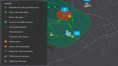
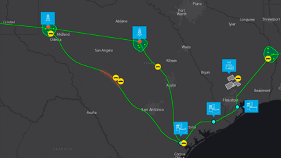
Obtaining a complete overview of what is happening in the territory, accurate, classified and orderly information for intelligent management in the supervision of security and inspection of assets, risk mitigation, obtaining reports on activities carried out in the area of influence, reducing security vulnerability, effective coordination of personnel and resources, and social linkage.
Modules
Our solutions are integrated by different modules, which can be customized and adapted to the user’s needs and operating rules, and are available individually or in packages.
- Certain points and scopes are conditioned to the existence of Territorial Management Studies, Plans and Programs, information provided, official information and open data from governmental platforms.
- The Services included in the modules only process data that are available on official sites and those provided by its clients, SmartGIS does not generate or produce any type of data or information unless the client requires a specific study.
Know the suitability of the land, visualize the UGA and UGT that regulate the territory, as well as the uses and destinations of land in accordance with municipal programs, reduce territorial conflicts and better manage the property and its resources. Natural Physical Environment
- Topography
- Soil science
- Hydrology
- USV
- UGA
Artificial Physical Environment (POT and/or PDU) Primary Zoning
- Strategic areas
- UGT
Secondary Zoning
- Sectors of activity
- Land uses
- Ownership and Reserves
Right-of-Way Management
- Ducts
- Highways and roads
- FFCC
- CFE
- Conagua
- Channels
- Others
Thematic Maps for consultation of current official programs.
Data from official sources
Innovative managers use maps and intelligent dashboards to achieve a holistic view of their assets. Location intelligence improves daily operations, such as inspections, maintenance and investment planning.
- Citizen Report
- Inventory of assets with information of general interest
- Real-time location tracking
- Tell stories with maps
Follow up incidents and prevent crime in your area of influence. Use location intelligence to see high-risk areas where your employees, service providers and customers transit, analyze the causes of incidents, establish patterns of action and optimize response plans and actions. Share information in real time with law enforcement agencies and implement actions to combat crime. Activate security and contingency networks in real time.
- Crime map
- Control panel
- Real-time incidents
Improve the operational awareness of the supervisors of the organizations in charge of industrial security. Prevent accidents due to damage and deterioration in your facilities. Reduce losses due to theft and act immediately against illicit acts within the areas of common services, roads and premises, maintain close collaboration with all those responsible for industrial security. Visualize the reports of services and incidents coming from the different collaborators, obtain historical reports of classified incidents.
- Damage and Impairment of Assets
- Streets, Racks, Fences, Drainage, Channels
- Signage, Traffic lights
- Pipelines, Casings, Valves
- Carcamos
- Warnings: Maneuvers, Drills
- Waste Report
- Extraction of bench materials
- Dismantling
- Crime map
- Inventory of assets with information of general interest
- Real-time location tracking
- View service and incident reports
Companies need access to reliable critical information, which will allow the organization to respond to incidents at different levels and in different units of care, this allows the industry to see beyond the horizon and react to incidents in real time, 24/7 access to incident data, corroboration from multiple sources, are vital for organizations that may have events of great social and/or environmental impact. Identify areas of natural and anthropogenic risks, locate incidents, delimit affected areas
- Risk Atlas (CENAPRED)
- Leaks and Spills
- Grassland burning
- High impact accidents
- Effective coordination of resources
- Delimitation of affected areas
- Damage count
- Citizen Report
- Inventory of assets with information of general interest
- Real-time location tracking
- View service and incident reports
Share your commitments and goals that contribute to climate action, make your employees and the community at large aware of the grand challenges of the 21st century and how your company is actively involved in achieving the goals of the NDCs and the SDGs.
- GHG Inventory
- Mitigation actions
- Adaptation actions
- Sanitation
- Environmental Services
- Concentrator page
- Inventory of assets with information of general interest
- Data Analytics
Drive technological innovation.
That its production not only generates income, but also leaves a legacy that contributes to sustainable development by producing the human resources required by its industry, the region and the country. Raise awareness among new generations and inspire their development.
- Teaching the student population and the general public
- Tell stories with maps
- Encourage research
- Link to the academy
- Boosting Talent (study and research grants)
- Concentrator page
- Tell stories with maps
Be a source of formal, truthful and timely information for the population and anyone interested in the sector, communicating what is happening in the fascinating world of the industry and its national and global linkages
- General information on the industrial sector to the population
- Information of the area of influence, national and global
- Production activities
- Industrial Zone GDP
- Volumes and Production Capacity
- Jobs generated
- Promote campaigns
- Interact with society
- Job Opportunities
- Concentrator page
- Data Analytics
- Inventory of assets with information of general interest
Phone
+52 5573847404info@smartgis.mx
Hour
9:00 am a 18:00 pm
Social Networks
Services
Business
Courses
- Arcgis Pro
- ArcMap
- Arcgis Online
SmartGis México
We develop knowledge at strategic planning levels through the use of GIS.
SmartGIS Copyright © 2022 . All Rights Reserved.