- SmartGis México
Precision Aerial Photogrammetry for Cartography and Topography works.
Capture of high resolution images of areas with Unmanned Aerial Vehicles (UAV), our highly qualified staff has RPAS pilot authorization granted by the General Directorate of Civil Aeronautics (DGAC), our flights have liability insurance coverage for drone operation.
- Survey for preliminary studies
- Road layout
- Volumetric calculations
- Contour lines
- Topography in difficult access areas
- Digital point cloud modeling
Benefits
Time reduction, increased efficiency in the collection of information, better cost-benefit ratio, eliminates risk to personnel in places that are difficult to access, generate Big Data and make comparisons at different times.
Services
Set of high-resolution photographs joined and georeferenced, restored in 2D using specialized software.
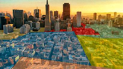
Locate properties with precision, carry out land zoning projects, update cadastral cartography, determine surface areas, measurements and boundaries, superimpose maps with information from land and urban development plans and programs and see the potential of your property, know the conditioning and limiting factors of your urbanization and/or building projects.
Perform surveys and 3D digital modeling of existing structures (as built) and terrain by means of a point cloud containing spatial position and color attributes, based on high-resolution images taken by drone.
tomadas por mediante drone.
Obtain a Digital Surface Model (DSM) with objects or elevations in different formats and different resolutions and accuracy, DSMs are the product of a 3D point cloud and 3D meshes from images.
Perform vulnerability analysis and studies, determination of micro-basins, flood and landslide zones, generate profiles and cross sections for engineering projects.
Perform quick and accurate volume quantifications at different scales, contour lines every 5.0m, 2.0m, 1.0m, or 0.5m.
The 3D textured mesh is a reproduction of the edges, faces, vertices and texture of the area filmed by the drone. This model is most useful for visual inspection or for presentation purposes
Phone
+52 5573847404info@smartgis.mx
Hour
9:00 am a 18:00 pm
Social Networks
Services
Business
Courses
- Arcgis Pro
- ArcMap
- Arcgis Online
SmartGis México
We develop knowledge at strategic planning levels through the use of GIS.
SmartGIS Copyright © 2022 . All Rights Reserved.